

Introduction
Addresscloud is a location intelligence platform serving the global insurance market. Founded in 2015, Addresscloud helps insurers understand geographic risk by providing high-quality data and advanced geospatial algorithms. Their API-first platform processes over 100 million transactions a month, offering high-quality accurate address geocoding, peril risk assessments, and property data intelligence. Addresscloud’s clients include more than 50 commercial and residential insurance companies, and they are a technology partner for Flood Re, the UK government flood reinsurer. The company operates with a fully remote team of staff across the UK, France, and Spain, and has been an Overture Contributor Member since October 2023.
Addresscloud joined the Overture Maps Foundation to leverage its open and interoperable data solutions. The decision was driven by the need for consistent building footprint data, available under an open license, and the global persistent identifiers provided by GERS (Global Entity Reference System).
These features were crucial for Addresscloud’s mission to scale their platform globally and improve the accuracy and reliability of their geographic risk assessments. Addresscloud has been operating in the UK for almost 10 years where their strategy has been to risk score every property in advance and cache the results. This provides customers with a more accurate risk assessment as it allows for different size buildings but also a very quick response as the results are pre-cached for very fast response times. Caching results also allows for high scalability employing Addresscloud’s serverless AWS architecture and replicating data across regions.
London is the global center of the insurance industry and many of Addresscloud’s customers insure properties worldwide both directly and via the Lloyds of London insurance market. Addresscloud needed to scale their solution globally to meet this demand and so finding a set of high quality global building footprints available under an open license and with a persistent identifier was key. Overture building outlines and the GERS delivered the exact solution Addresscloud needed and the timing was perfect.
Challenges and Solutions
Addresscloud needed to ensure their platform could handle large volumes of transactions quickly and accurately. They also required a global set of consistent building footprints and a globally persistent identifier to scale their platform effectively. The integration of GERS provided Addresscloud with the necessary framework to manage these challenges. GERS IDs offered a consistent and persistent identifier for each building, regardless of changes in attributes or geographic conditions, enabling Addresscloud to maintain high data accuracy and reliability.
Deployment and Results
Addresscloud joined the Overture Maps Foundation as a contributor, actively participating in the community and leveraging the open data provided. They began with a proof of concept in mainland Europe, using the GERS to pre-calculate flood risk scores from their partner, JBA Risk Management. Addresscloud processed 300 million building footprints against over 200 flood raster files ranging from 30 meter to 5 meter resolution covering 6 return periods for both fluvial (river) and pluvial (surface) flooding. In addition to the GERS, Addresscloud have built a multi-resolution H3 hexagonal fallback for areas lacking building footprints and deploying the solution on an AWS-hosted serverless cloud platform, Addresscloud successfully launched the system in production in March 2024 and has been well received by customers who are now asking for more perils in more geographies.
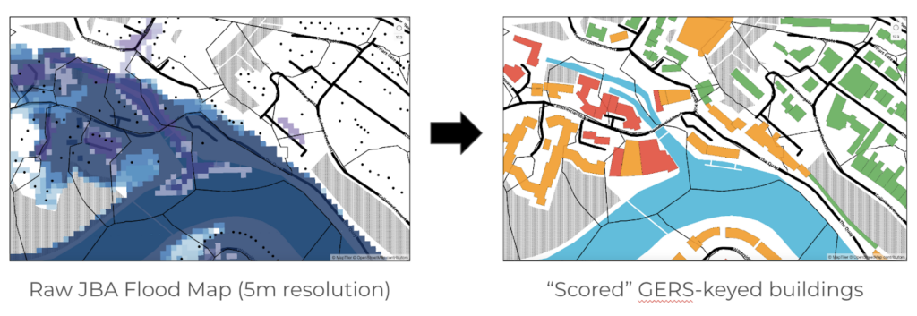 The integration led to flood scores for 300 million buildings, with 2 billion more to process. Addresscloud achieved sub-200ms performance at scale, providing high-quality risk scores and enhancing customer satisfaction. The proven technique is now extendable to any geography and peril, showcasing the scalability and efficiency of their solution. In addition to peril scoring buildings the Overture building outlines allow Addresscloud to build a global set of “fire accumulation” blocks simulating a 5 meter fire spread which helps insurers to better manage their concentrations of risk and to avoid risks before going on cover to reduce reinsurance costs.
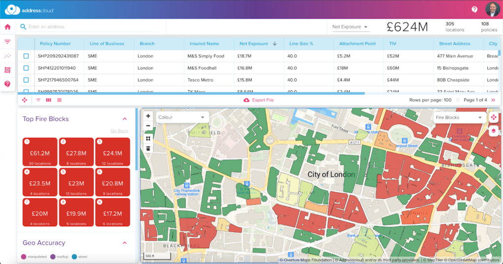
The Addresscloud Risk platform showing fire accumulation blocks based on Overture data
Insights and Forward-Looking Statements
“Overture Maps and the GERS came at the perfect time for us, they gave us a spatial backbone to be able to risk assess and cache buildings globally improving accuracy and performance for our insurance customers.” Mark Varley, CEO, Addresscloud
GERS enabled Addresscloud to significantly enhance their data accuracy and performance in risk assessments. The persistent identifier was crucial to be able to pre-cache data and minimize the amount of changes required to maintain a global set of risk scores. The quality of the data is high and the open license allows insurers to evaluate a large number of risks without incurring significant expense which is key in an increasingly digitally traded market. Addresscloud aims to have “cached the world” by the end of 2024 using Overture buildings and the GERS as their spatial backbone.
In addition to flood risk Addresscloud will be working with other datasets from their network of commercial partners and open source government data including wildfire, earthquake, volcano, topical cyclone and other key climate-related perils. In additional to geographic risk data Addresscloud will use Overture building attributes such as height and footprint and will assign additional attributes to the GERS including age, construction type and use.
In the future, as Overture Places data improves Addresscloud plan to use this data to help insurers understand adjacency risk looking at not only the use of a specific building but the adjoining buildings to understand if high risk trading activity is being undertaken close by. Addresscloud currently work with partners for geocoding outside of the UK and Ireland but are following the Overture Address theme with interest and plan to undertake a proof of concept in 2025 to build an AI-powered geocoder to improve quality in key geographies which are not well server through existing solutions.
Conclusion
By integrating Overture building footprints and the Global Entity Reference System (GERS) into its platform, Addresscloud has significantly enhanced its ability to provide precise and rapid geographic risk assessments for the insurance industry. Leveraging Overture Maps Foundation’s open and interoperable data solutions, Addresscloud has achieved rapid response times at scale and improved customer satisfaction with high-quality risk scores. This integration has enabled Addresscloud to scale globally, addressing various perils such as flood, fire, and earthquake risks, and maintaining high data accuracy and reliability through consistent building identifiers. The combination of Addresscloud’s innovative approach backed by Overture data and highly scalable cloud computing have delivered better decision-making and improved risk management for insurers worldwide.