

One of our goals at Overture is to make geospatial data easier to work with. We want to help geospatial experts and data generalists easily connect to our datasets and, in turn, facilitate data sharing among them all. This is why we spend so much time on our persistent Global Entity Reference System, or GERS.
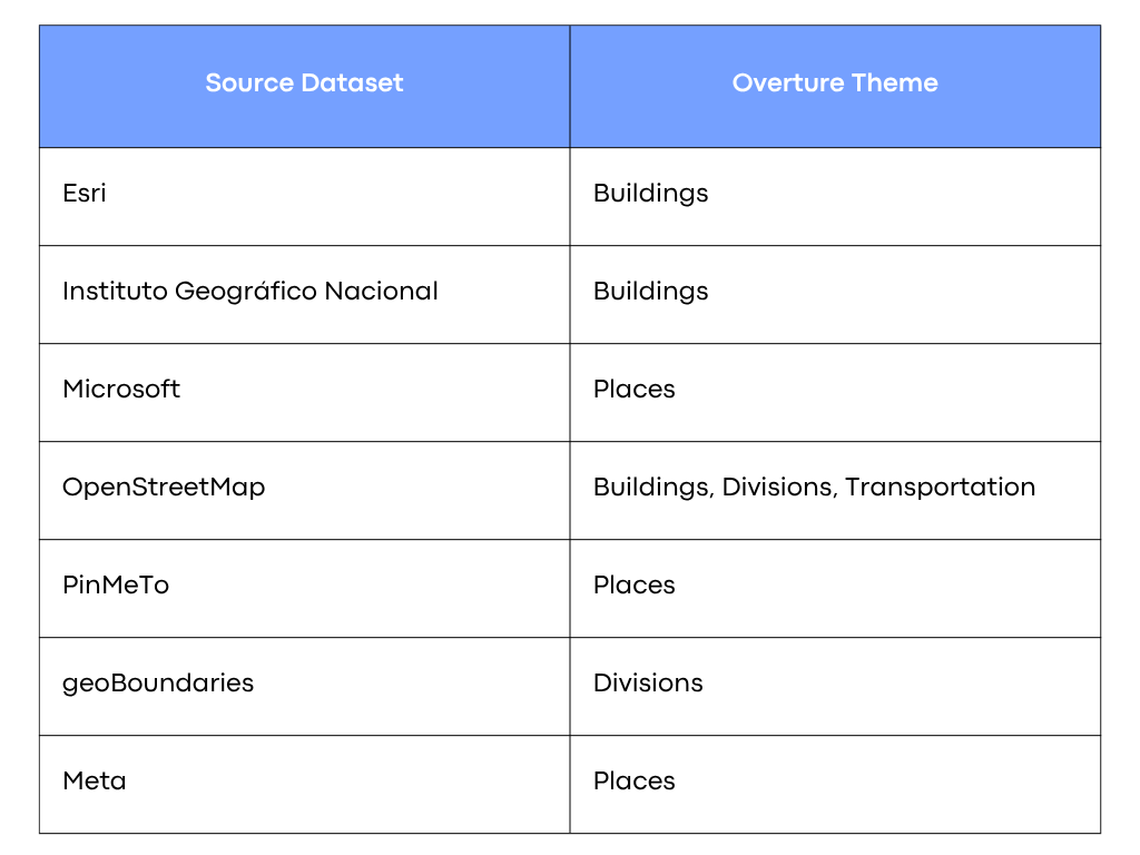
Last month, Overture introduced a new set of data artifacts to help teams connect to 3rd party input datasets we use to create Overture data releases. Bridge files are available for seven source datasets, connecting their respective identifiers to the specified Overture themes.
 We’re releasing bridge files to support three key use cases:
- Bridge files make Overture onboarding easier
- Bridge files make enriching Overture data easier
- Bridge files increase data transparency
Let’s take these in order.
Bridge Files Make Overture Onboarding Easier
If you’re already using and/or connected to any of these source datasets, you can easily connect to Overture data and GERS identifiers by using bridge files as a join table.
For example, let’s say you’re an adtech company that uses Facebook page IDs to identify businesses and run ad campaigns. Downloading or querying Overture’s Meta bridge file will enable you to connect your records to Overture GERS IDs with a single column join.
For example, using DuckDB:
SELECT * FROM read_parquet('s3://overturemaps-us-west-2/bridgefiles/2025-05-21.0/dataset=meta/theme=places/type=place/*.parquet') AS bridge JOIN your_table AS yt ON bridge.record_id = yt.meta_id;
Change your_table to, well, your table and you’re good to go. Store the bridge.id column from this query and your data is now associated with GERS identifiers. You can quickly append Overture map data to your records, export your data keyed against common GERS identifiers, and onboard 3rd party GERS-mapped data.
Bridge Files Make Enriching Overture Data Easier
If you’re already using Overture data, you can use Bridge files to quickly connect to any source dataset.
Again, let’s use the Meta/Places Bridge file for a quick scenario. Let’s say you have a restaurant finding app that uses Overture Places data for your restaurant listings. Connect to the Meta Bridge file and use the provided Meta ID to query Facebook’s Graph API to obtain star ratings for a venue.
Bridge Files Increase Data Transparency
To produce our data releases, Overture ingests and conflates multiple datasets to produce each of our six themes. Where possible, we attempt to carry forward and cite all data entities associated with a single record, but in many cases, an input datapoint won’t make it all the way through our pipeline.
For example, in our buildings pipeline, if we determine two building records from two different data sources likely to refer to the same building, we will only persist one of these records in our final release. Both sources know about each building, but only one data point and ID make it into our final theme.
Bridge files allow you to associate all input data sources with our final data records, allowing you to understand which elements are informed by OpenStreetMap, Esri, and the Instituto Geográfico Nacional. (Google Buildings and Microsoft Buildings datasets don’t contain identifiers, so we’re unable to create a Bridge file for them).
In addition to providing as much transparency as possible, Bridge files enable you to port your efforts into another ID ecosystem, should you so desire. We don’t want GERS to become yet another ID system that relies on lock-in. We want you to embrace GERS because it works, not because you have to.
🔍 Want to learn more about GERS?
Read our GERS Deep Dive blog to understand how the system works.
🔗 Ready to connect your data to GERS?
- 🛠 Do it yourself
- Get started with the GERS tutorial and check out our bridge files for fast onboarding.
- 🤝 Work with onboarding partners
- Our members and ecosystem partners like TomTom, Esri, Precisely, Wherobots, Carto, and Fused offer onboarding services to help you connect faster. Learn more.
🌍 The future of mapping is open, collaborative, and built together.
Join us in making it happen.