
If you have ever followed a map to a storefront only to end up standing in an empty parking lot, you have experienced the limits of traditional geocoding. Like other commercial and open Point of Interest (POI) datasets, Overture Places has historically relied on standard geocoding approaches – but these tools often struggle with shared addresses, outdated databases, uneven street distribution, and map alignment errors.
As a result, POIs are frequently pushed into parking lots, adjacent properties, empty spaces, or even the middle of the street, failing to match the real-world entrance. In some data samples, nearly half of the POIs do not sit inside a building footprint at all. To unlock advanced spatial use cases, improving the geometric precision of these POIs is essential.
Anchoring map data to reality
To tackle these exact spatial errors, Zephr collaborated with other Overture members to form the Places Imagery Task Force. The team built a computational pipeline that utilizes Mapillary street-level imagery, conflated with Overture’s IDs (“GERS”, Global Entity Reference System), to anchor POIs directly to the physical world. Because street-level images are visually anchored to reality, they successfully bypass the loose, often imprecise spatial nature of traditional address ranges. This initiative not only improves the geolocation of existing POI data but also detects additional POIs currently missing from the database.
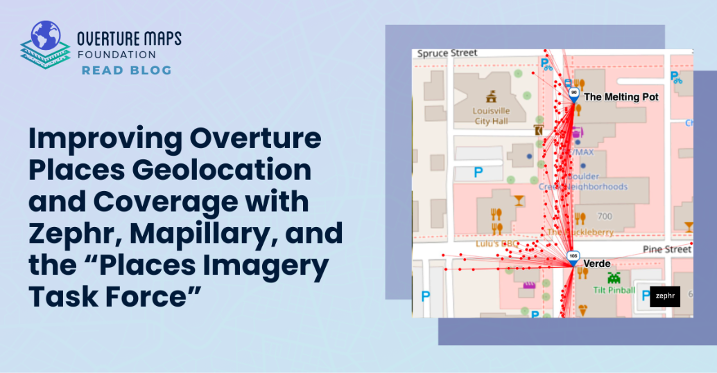
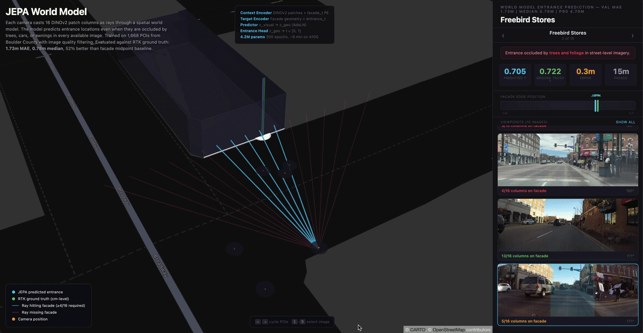
The core of this solution is a method called relocalization. Instead of just placing a pin based on a text address, this technique inverts the visual positioning problem by using multiple images to determine the precise location of a POI. By tracing lines from the camera’s position back toward the photographed subject, we can pinpoint the exact coordinates where those lines crossed.
Achieving this required a few critical technical milestones. First, the pipeline identifies street-level images containing an Overture POI using a Meta-developed detection model. It then structures the required data by capturing the camera pose, geotag, heading, and pitch for each image. Using these data points, the system determines multiple image rays to compute the best crossing point in 2D space , ultimately intersecting the resulting ray with the closest visible building facade.
Proven precision and expanded recall
This pipeline has drastically improved the spatial accuracy of Overture’s data in the pilot area. By triangulating image data, POIs are relocated directly to their physical storefronts. Initial tests conducted across Boulder and Louisville, Colorado, showed immediate impact: the median distance error was reduced from roughly 4.5 meters to just 2.3 meters. With further iteration on the model, that median error was pushed down to an impressive 1.5 meters.
Beyond just moving pins, the relocalization pipeline drove several downstream data enhancements. It successfully aligned the optimized POI coordinates with specific building features using GERS. It mapped entirely new places missing from the current Overture database by identifying imagery with place indicators , and detected business turnover by matching new signage against historical street views. The team even created cross-view embeddings that link street-level visual data with aerial imagery to verify building tenants.
Future capabilities and global scale
Having proved the core relocalization methodology in these initial test cities, the goal is now to extend this pipeline to unlock broader spatial intelligence and scale the architecture globally. The immediate next steps include scaling the model sequentially – moving from initial test cities to more cities, international markets, and eventually aiming for total global coverage.
As the project expands, the team plans to extract specific building entrances and associate them with the correct GERS identifiers. They will also integrate regression models to handle data points where the exact location remains highly uncertain, and train models to identify structural damage or facade modifications by comparing new street-level images with baseline aerial data. Finally, to make this system highly efficient, there are plans to execute the relocalization pipeline directly on edge devices, processing metadata locally to bypass cloud computing costs. The totality creates a foundation for grounding AI in the real world by conflating vectors, rasters, and language through multimodal embeddings.
Join the Overture Community
Overture is focused on providing a structured, vendor-neutral data foundation to help ensure future AI systems are accurately anchored in physical reality.
Join the Overture Maps Foundation as a member to shape how AI and LLMs get grounded in the real world. Visit the Overture website to learn more about how your organization can become a member. To stay updated on our latest schema releases and AI tooling, sign up for our monthly newsletter or follow us on LinkedIn, X, and Bluesky.