


Introduction
Established in 1969, Esri is a global leader in geographic information system (GIS) technology. The company provides comprehensive and scalable digital mapping and analytics software, known as ArcGIS, which is used by over 650,000 customer organizations worldwide, including Fortune 100 companies, national governments, and educational institutions. Esri is committed to sustainable growth and invests significantly in research and development to continuously advance the field of GIS.
Use Case Overview
Esri joined the Overture Maps Foundation as a General Member in 2023, actively participating in working groups to help create a global open database. Their goals include enhancing visualization, geocoding, and analysis capabilities while integrating authoritative GIS data such as buildings, addresses, and roads to support their users.
Problem-Solving
Esri aimed to enrich their building datasets by leveraging the open and interoperable data provided by Overture Maps. They focused on integrating the Global Entity Reference System (GERS) IDs into their datasets to ensure consistency and improve the quality of their mapping solutions.
Challenges and Solutions
Esri worked on enriching the Overture Buildings dataset, which includes over 2.3 billion buildings in a simple schema with GERS IDs, by integrating FEMA’s USA Structures dataset. This dataset includes 75 million structures with rich attributes such as occupancy, address, and height.
One challenge was creating a correspondence between the Overture GERS ID and the USA Structures UUID, which could then be used to join attributes from the separate datasets.
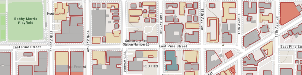
Figure 1: Overture Buildings by ‘class’ and displayed with USA Structures outlines
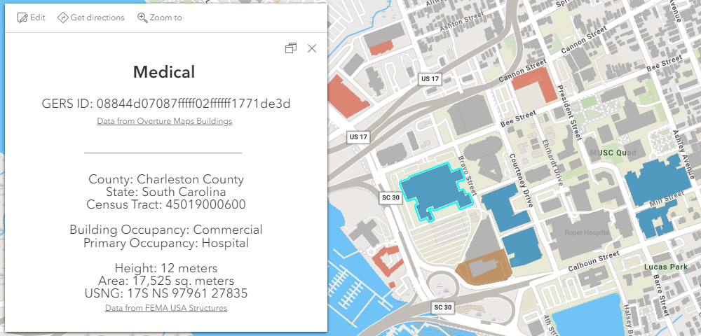
Figure 2: Pop-up for Overture Buildings layer, with info from USA Structures layer
This is a significant geoprocessing task given the size of the respective datasets. Esri developed an initial prototype for four U.S. cities and later expanded it to all contiguous 48 states. They performed a spatial join, appending GERS IDs to the USA Structures, achieving a 98% match rate for approximately 330,000 structures in the prototype. This integration allowed them to publish a web map with custom pop-ups and create a web app for enhanced data visualization.
Deployment and Results
Esri joined the USA Structures (Join Layer) with Overture Buildings (Target Layer) based on GERS IDs, enabling detailed visualization of attributes like building occupancy and 3D representations. This integration provided a fuller understanding of the data, enabling new use cases for the data such as thematic mapping and 3D visualization and analysis.
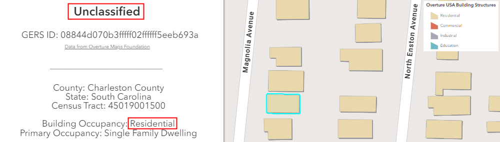
Figure 3: Map layer of Overture Buildings symbolized by attribute in USA Structures
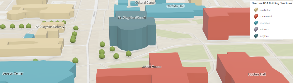
Figure 4: Scene layer of Overture Buildings extruded by ‘height’ value in USA Structures
The integration of GERS IDs allowed Esri to publish enriched feature layers and create custom visualizations. They achieved a high match rate and provided additional attributes for better visualization and data analysis. This exercise demonstrated the feasibility of GIS professionals using Overture data to spatially join with other datasets at scale (tens of millions of features) and then use the Overture GERS ID to efficiently join attributes between datasets. This can provide a much richer and more spatially accurate dataset that can then be used to support additional types of visualization and analysis to support better decision making.
Insights
The use of GERS significantly improved Esri’s data integration process, making it easier to access information from related datasets. The enriched datasets facilitated better visualization and analysis, enabling further exploration and understanding of the data. Esri plans to continue leveraging GERS IDs in future data releases, expanding their coverage and enabling more use cases. This includes integrating GERS IDs into other themes such as transportation and places, further enhancing their mapping capabilities and supporting a wide range of applications. We are delighted to have persistent GERS IDs now integrated into Overture Buildings, not only due to the enhancements of the Overture dataset for our map production use, but because of the promise it holds for ArcGIS customers that want to enrich this type of data,” said Deane Kensok, Esri ArcGIS Content CTO. “This integration will be invaluable for future applications in fields like urban planning and infrastructure, where the ability to maintain and combine accurate and up-to-date information about structures is crucial.
Conclusion
By integrating GERS into a nationwide open buildings dataset, Esri has demonstrated how GIS professionals, such as National Mapping Agencies, can leverage Overture data in their workflows to produce richer datasets that support new use cases. This case study demonstrates the value of GERS in enabling seamless data integration and improving the accuracy of geographic data, ultimately supporting better decision-making and planning across various sectors.