

Introduction
TomTom is a global leader in location technology, providing mapping and navigation solutions to various industries, including automotive, fleet and logistics, and location analytics. Their mission is to create the most accurate and up-to-date maps to power navigation and location-based services worldwide. TomTom, as a Steering Member of Overture, provides its Transportation Network data to Overture, which includes maps of roads, railway and ferry routes, pedestrian paths, and other modes of travel. Moreover, TomTom generates the Global Entity Reference System (GERS) IDs for the Transportation network. Today, the Transportation Network is primarily sourced from the OpenStreetMap (OSM), which has been normalized and cleared of any data inconsistencies.
Use Case Overview
TomTom co-founded the Overture Maps Foundation (Overture) to tackle the significant challenges and evolving demands in the geospatial industry. While many companies can achieve initial map accuracy, the real challenge lies in refining and perfecting the remaining details. TomTom recognized that the best way to meet these evolving needs was through a collaborative approach, which led to the creation of Overture. A critical component of Overture is the GERS, which provides a universal framework for structuring and matching map data across different systems. This framework addresses the fragmentation issue where data in one mapping system could not be easily communicated or integrated with others. By establishing Overture and promoting open collaboration, TomTom aims to create a more interconnected and innovative mapping ecosystem that benefits the entire industry. In generating GERS IDs, the primary challenge is to uniquely identify every road worldwide. To tackle this, it’s crucial to establish clear rules for determining when a geometric change necessitates assigning a new GERS ID. The following details how we uniquely identify each road and assign a unique GERS ID. This method ensures that various services maintain a consistent, long-term association with the transportation network.
Challenges and Solutions
The OSM requires that every road be split whenever its attribution changes along the way. This approach simplifies the editing process for mappers, preventing mixed attribute values on a section. This model also makes it easier to track the version history of each section over time. To further dive into the technical side of the OSM sectioned model, check this blog post. However, as attributes change over time, the number of sections within a road also increases. For instance, in the United States in 2023, due to changes in road lighting, 103 million new sections were added to the network. Each time a new section is introduced, the data associated with that section must be updated. This remains necessary even if an attribute change doesn’t directly impact the application. To illustrate this challenge, consider an example of direction of traffic flow being linked to a road network.
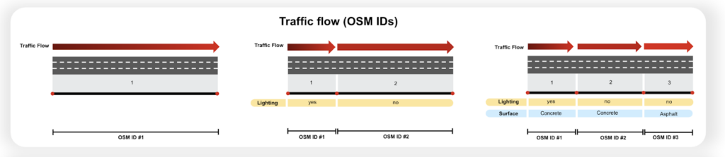 On the left, traffic flow information corresponds to a specific road section. When the lighting conditions of the road change, an attribute is added to the road, resulting in a new section. Consequently, the associated direction of traffic flow must be updated to link to two sections, as shown in the middle. On the right, further attribute changes, such as in the road’s surface material, necessitate another update in the direction of traffic flow connected to that road network. Note that the traffic flow remained unaffected by changes in attribution. Nonetheless, the data association still required updating. Regular updates to the mapping between data and the road network are costly for application developers.
To address the above challenge, GERS IDs are designed to be associated with uniquely identifiable roads that emphasize the geometric identity of the road over its attribute variations. Let us guide you through the GERS generation and creation of these uniquely identifiable roads. First, we introduce split points at selected network intersections, such as junctions, to ensure consistency across the network. We select these intersections because we believe they influence all geospatial applications, necessitating a split.
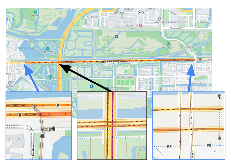 The image above provides an example where the sections are introduced to the road network:
- Sectioned (Blue): intersection of two major roads indicating a routing decision point. A vehicle can merge into traffic from either side.
- Not sectioned (Black): Crossed Road is a bridge not impacting the selected road geometry.
- Sectioned (Blue): The crossing of two major roads indicates a routing decision point. A car can turn to a different road depending on its destination.
Next, we merge all road segments, introduced due to attribute changes between two intersections, by using a method called linear referencing. For a more detailed understanding of linear referencing, refer to this Overture blog, where the concept is explained. To illustrate how this uniquely identifiable road associated with GERS ID helps with data association, let us revisit the traffic flow example.
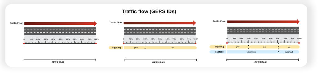 On the left, the direction of traffic flow is associated with a road network. Changes in lighting conditions are indicated using the linear referencing concept. Here, changes are pinpointed with a percentage from the start of that section without creating a new section. The previously associated direction of traffic flow remains valid and doesn’t need to be updated. On the right, despite the introduction of more attribute changes, the direction of traffic flow remains associated with the initially linked GERS ID and requires no updates. This is primarily due to the unique assignment of GERS IDs to geometry, making it independent of attribute changes.
Insights and Forward-Looking Statements
GERS IDs enable data interoperability within the Overture transportation network. The stable GERS IDs facilitate better integration and management of diverse datasets associated with the transportation network.
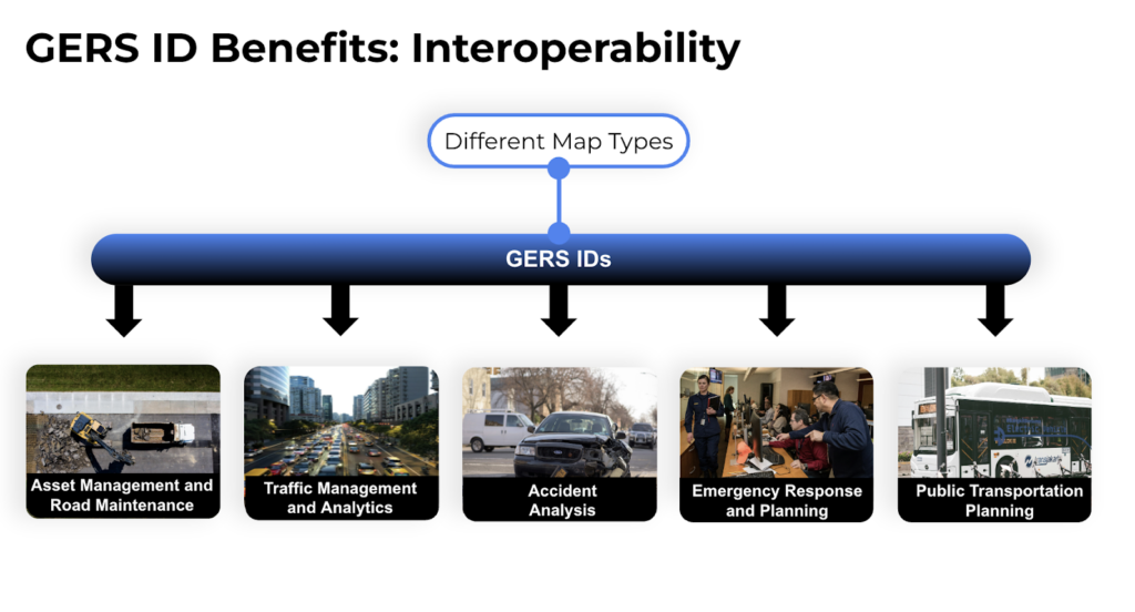 GERS IDs facilitate a wide range of applications, including asset management and road maintenance, traffic management and analytics, accident analysis, emergency response, and public transportation planning. With the introduced interoperability, Overture users can provide more comprehensive and integrated solutions to their clients.
“In the future, GERS IDs representing uniquely identifiable roads enable interoperability and integration of different geospatial datasets, unlocking new possibilities for geospatial applications. We will extend our guidelines for identifying which types of geometric changes warrant the assignment of new GERS IDs.” said Siavash Shakeri, Maps Product Manager at TomTom.
Conclusion GERS provides a universal framework for structuring and matching map data across different systems, addressing the challenges observed with the OSM Sectioned model. A challenge in generating GERS IDs is uniquely identifying every route worldwide. GERS IDs enable data interoperability within transportation networks, facilitating better integration and management of diverse datasets associated