

By Will Mortenson, Executive Director, Overture Maps Foundation
When I joined Overture Maps Foundation as Executive Director, I knew I was stepping into something special. After 27 years in the geospatial industry, including two decades at the National Geospatial-Intelligence Agency, I’d seen firsthand what happens when subject matter experts from different fields label features on the map. For example, a lighthouse is a feature that is important for a topographic map, but equally important for a maritime or aeronautic chart, however, each of these maps have different schemas and standards. This results in three versions of the same feature instead of one.
Every organization in this industry faces the same challenge. We all generate the same features independently. We all struggle with conflation,the expensive, time-consuming process of matching data across datasets. We all pay what I call the “conflation tax.“
Three years ago, AWS, Meta, Microsoft, and TomTom came together to change that. Their vision: create open, reliable, and interoperable map data infrastructure. Build the foundation once, together, and let everyone focus their resources on the innovation that creates real differentiation.
Three years later, the results are tangible, measurable, and visible across the ecosystem.
Building the Open Foundational Map Layers
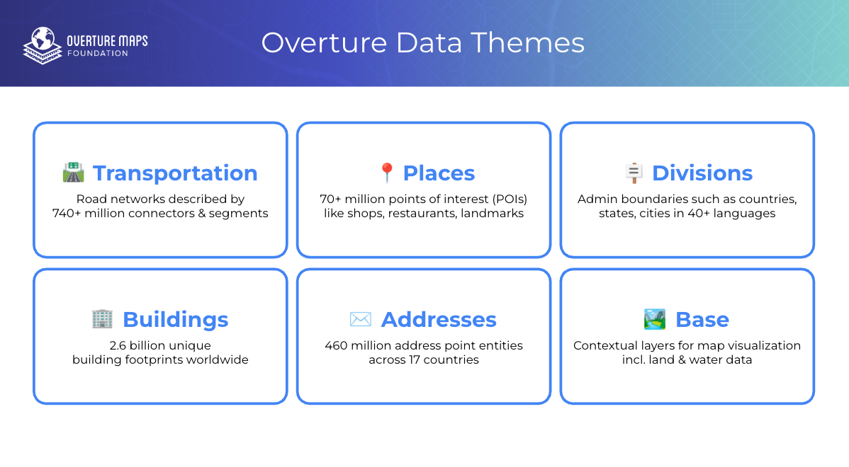
Overture creates a common foundation of map data. We bring together open data from crowdsourced, government, and machine learning sources, then do the work of normalizing it to a single schema and conflating it so you don’t have to. The result is six data themes that serve as a common way to reference the same features on earth, making it easier to link and combine data across organizations.
Today, Overture’s open datasets include:
- ~2.6 billion building footprints spanning the globe
- 70+ million places of interest with growing coverage and confidence
- 740+ million kilometers of segments and connectors in our transportation network
- 460+ million addresses across dozens of countries
- Administrative boundaries and base theme features providing essential context
 All of this data is open, free to use, and updated monthly, and we’re always looking to incorporate more sources. Anyone can download it from our website or access it through cloud platforms like AWS, Google BigQuery, Snowflake, and Databricks.
Just as important, we committed early to modern, cloud-native formats like GeoParquet, making Overture data easier to use at scale from day one because we want our data to be usable where real work happens.
We’ve moved from pre-release alpha data in April 2023 to General Availability across the majority of data themes today. Companies including Addresscloud, Esri, Meta, Microsoft, Niantic, Precisely, Regrid, TomTom, Tripadvisor, and Uber have incorporated Overture datasets into services and products reaching billions of users. Meta integrates Overture data directly into the map experiences on Facebook and Instagram, Esri adopted Overture buildings and administrative boundaries as default layers in ArcGIS, and Microsoft re-indexed global data using Overture datasets.
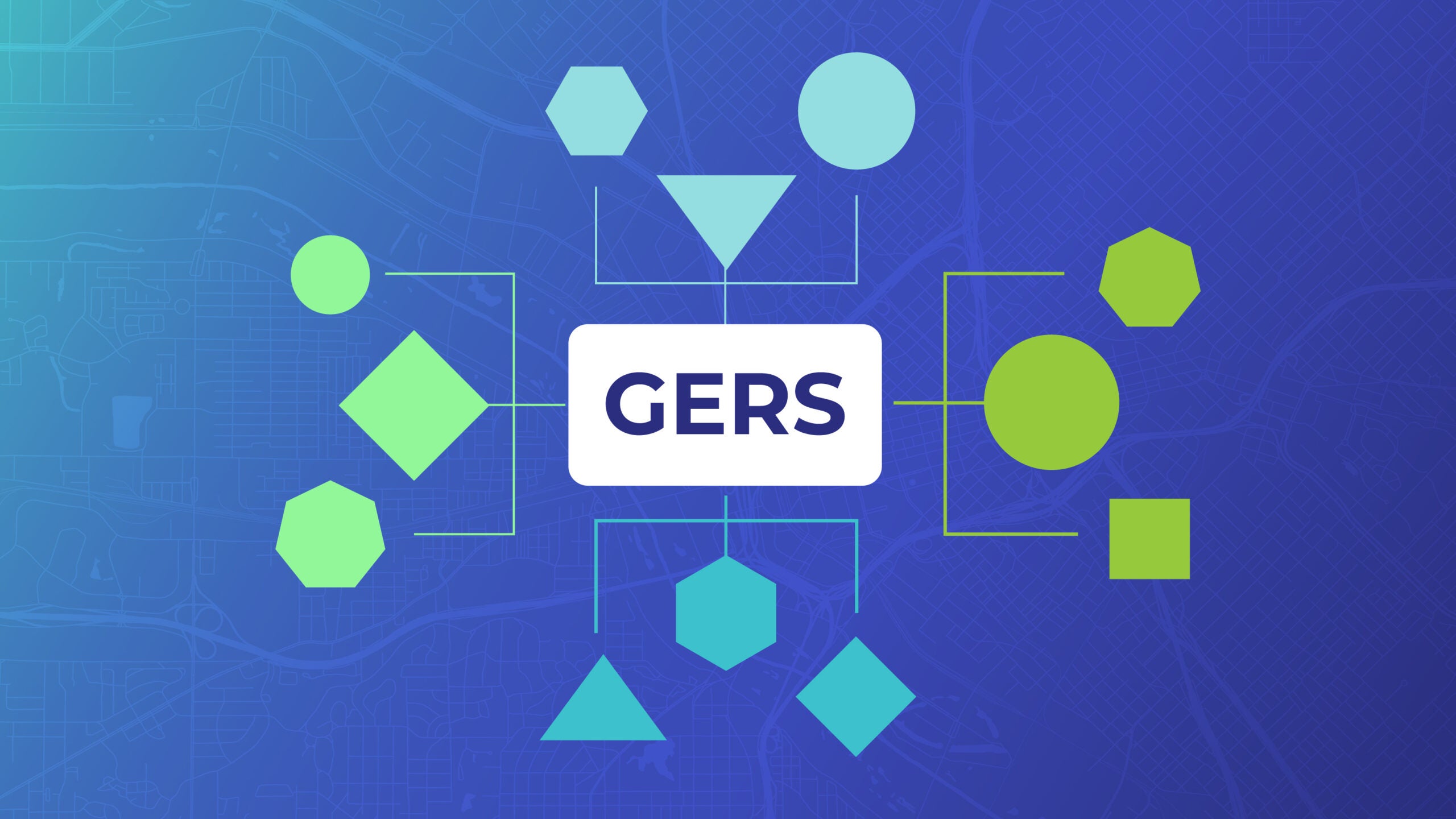
GERS: The Backbone of Interoperability
If our datasets are the body of Overture, the Global Entity Reference System (GERS), is the spine.
GERS gives every feature a unique, stable identifier. Think of it as a universal address system for geographic entities. When a hotel has a GERS ID, Tripadvisor can reference that ID in their ratings data, Uber can use it in their drop-off analytics, and a city planning department can link it to permit information, all referencing the same entity without expensive conflation work.
This is the main reason I joined Overture. In a future where automation and AI generate ever-larger volumes of geospatial data, success isn’t about who can map a feature, it’s easily connecting what you know about that feature to what everyone else knows. GERS makes that possible.
Over three years, we’ve taken GERS from concept to reality:
- 2023: Published V1 specification; deployed stable IDs to 1.6 million buildings across 8 cities as a proof of concept.
- 2024: Expanded GERS coverage across all themes; moved to beta stability.
- 2025: Achieved General Availability; transitioned to standardized UUID format, launched tooling and infrastructure to make GERS useful and traceable
We’re now working with the Open Geospatial Consortium (OGC) to establish GERS as an official community standard, which would pave the way for all organisations to work with GERS to reach their goals.
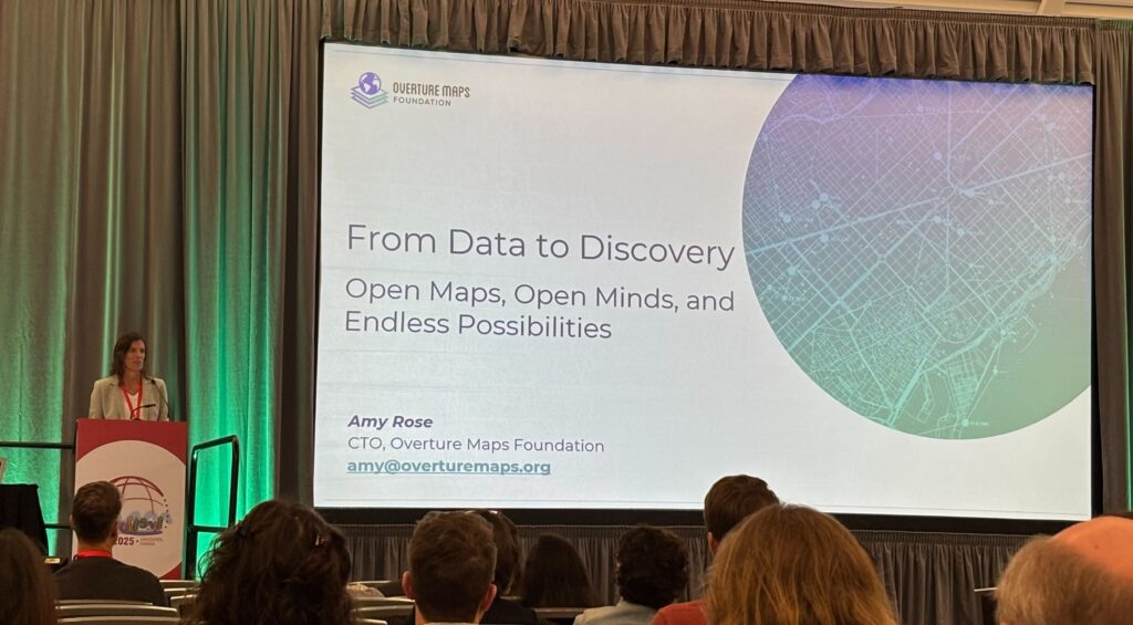
 Member Summits: Where the Community Connects
Some of our most important work happens when the community gathers in person.
Our 2024 Member Summit in Ghent brought the community together for the first time, establishing the collaborative culture that defines Overture.
The 2025 Summit in Charleston expanded on that foundation, with over 120 participants from 30+ member organizations gathering for three days of intensive collaboration. The Charleston summit marked a pivotal shift in our narrative: from “building the best open map” to “enabling the best map.” As Albi Wiedersberg, our VP of Product, explained: there’s no single “best map” for all use cases. Overture’s role is to provide the Reference Map, the ID System (GERS), and the framework that allow specialized solutions to be built on a trusted foundation.
This April, we’re heading to Florence, Italy. If you want to be part of shaping the next chapter of map-making, join us as a member, I hope to see you there.
 Industry Presence: Building Visibility Across the Geospatial Ecosystem
Over three years, Overture has established itself as a consistent voice in the global geospatial conversation. We’ve participated in 30+ industry events across four continents, moving from introducing ourselves to leading discussions on the global mapping infrastructure..
Our presence spans the full spectrum of the geospatial community:
Enterprise and business forums like Geospatial World Forum and Cloud-Native Geospatial Forum, have become an annual platform for deep conversations on managing the explosion of spatial data.
Major GIS conferences including the Esri User Conference, where Overture was featured in the plenary session and our data is now integrated into ArcGIS Living Atlas, making it accessible to millions of ArcGIS users worldwide.
Open source and community gatherings like State of the Map (US, EU, and global), FOSS4G, and FOSS4G SotM Oceania, where we engage with the OpenStreetMap community and demonstrate how Overture uses and contributes back to grassroots mapping efforts.
Government and standards bodies including the GeoGov Summit, OGC Member Meetings, and OGC Innovation Days, where we collaborate on National Spatial Data Infrastructure modernization and advance GERS toward formal standardization.
This sustained presence has paid off. We’ve moved from explaining what Overture is to fielding questions about implementation details. Industry leaders now cite us in discussions about spatial data infrastructure. And increasingly, we’re invited to lead panels, deliver keynotes, and host workshops.
The conversations have evolved too. Early discussions focused on whether open collaboration among competitors could even work, and why open data was a good idea. Today, they focus on how to accelerate adoption and what comes next.
 Industry Recognition
The broader industry has taken notice of our work.
Fast Company’s 2025 Next Big Things in Tech: Overture was recognized in the “Small and Mighty” category, honoring smaller teams achieving outsized impact through innovation. This places Overture alongside technologies reshaping industries and improving lives—one of the most competitive and respected awards in media and technology.
GeoGov Public-Private Partnership Award: This recognition underscores how Overture’s open, multi-sector model helps modernize how geospatial data is created, shared, and applied for societal benefit.
Our digital presence tells a similar story of growing momentum:
- Nearly 400K website visits (up 70% year-over-year)
- 3.4 million Google search impressions
- 14K social media followers growth
- Newsletter open rate of almost 50% (vs. 30% industry average)
- Monthly newsletter subscribers more than doubled year over year
These metrics matter because they reflect growing awareness that open, interoperable map data isn’t just an idealistic vision, it’s becoming infrastructure.
The Technical Foundation
None of this would be possible without rigorous technical execution. A few highlights from three years of engineering:
- Monthly release cadence established in July 2023 and maintained ever since
- Cloud-native formats (GeoParquet) adopted for efficient data access, analysis, and integration
- Full pipeline migration to Overture’s platform agnostic infrastructure, ensuring long-term sustainability
- Schema v1.0.0 released, signaling production stability
- Developer tools including Explorer, Python command-line interface, and open source utilities like the transportation-splitter
- Data warehouse integrations with BigQuery, Snowflake, and Databricks for enterprise analytics
- Quality frameworks defining recall, precision, and benchmark metrics across all themes
From assembling data to building infrastructure. In year one, we focused on aggregating sources and proving the concept could work. In year two, we migrated pipelines, stabilized schemas, and reached General Availability across most core themes. In year three, we operationalized GERS with a Registry bridge files, and a data changelog, integrated new data sources, and began laying the groundwork for AI-ready geospatial data. Each phase built deliberately on the last, creating not just datasets, but a technical foundation designed to scale with the industry’s evolving needs.
 What Comes Next
Three years in, Overture has proven that the industry can collaborate on shared infrastructure to accelerate innovation. We’ve built the datasets, established the interoperability standard, and created the contributor ecosystem.
Now we scale. Our priorities for 2026:
- Expand GERS adoption industry-wide, including OGC standardization
- Grow our datasets – with more contributors, more data and signal contributions, and improved data quality and confidence
- Deepen AI/LLM partnerships to position Overture as the foundation for model grounding and spatial AI
- Extend our global footprint, particularly in Asia and with international government organizations
- Make adoption easier with better tools, documentation, and onboarding
Ultimately, Overture exists to solve a problem the industry has struggled with for decades. If we do our job well, organizations will spend less time on conflation and more time on innovation. GERS will become infrastructure people rely on without thinking about it. And the map of the world will be more connected, more interoperable, and thus a lot more useful for everyone.
Join Us
Three years ago, four companies started building a shared foundation for open map data. Today, more than 40 organizations are contributing to build something together none of us could build alone.
If you’re not yet part of the Overture community, I invite you to explore what we’ve built. Our data is open and available: download it, test it, build with it. If you’re ready to become part of the solution, consider becoming a member.
And join us at the 2026 Overture Member Summit in Florence this spring. It’s where this community comes together to collaborate, share, and move the work forward, and it’s a ton of fun.
The map of the world is being rewritten, collaboratively. Come write the next chapter with us.
Visit our website to learn more about our work and become a member.
Stay connected: follow us on LinkedIn, X, and Bluesky for the latest updates. Sign up for Overture’s monthly newsletter for the latest updates on our journey in transforming map data distribution.
Interested in using Overture data? Check out the Explorer tool, a no-code option for inspecting Overture data and metadata, the data guides for an overview of our six data themes, and the “Getting Data” section of our documentation.