

How two local governments contributed data to Overture – and got GERS IDs back
Introduction
Authoritative local geographic data is the foundation of urban functions, municipal logistics, and public safety. But the public sector agencies responsible for managing this data face complex challenges, including incompatible data silos, proprietary schema constraints, and technical or budgetary limitations.
This case study will explore how two public sectors partnered with Overture Maps to tackle challenges, demonstrating the value of open, interoperable map data:
- The City of Vancouver (working in collaboration with Esri Canada): Responsible for urban planning, roads, and public works, among other things. The City of Vancouver maintains detailed geospatial datasets of all of these key parts of physical infrastructure to support resilient urban development and long-term asset management.
- Fresno County, California (Public Works and Planning Department): Functions as the local addressing authority, mapping a vast, topographically complex terrain spanning over 6,000 square miles – including the heavily forested Sierra Nevada mountains. Precise location data here is mission-critical for emergency rescue operations and partners like CAL FIRE and the National Emergency Number Association (NENA).
The Challenge
Rigid Schema Constraints and Manual Labor
Public organizations face significant administrative overhead from manually conforming, re-shaping, and siloing their localized data to match the rigid, non-interoperable schemas required by various state, federal, or private commercial mapping applications.
In Fresno County, matching native county files to the consumer applications emergency responders actually use in their vehicles demanded heavy manual translation labor:
“The world of mapping and data distribution for government agencies has completely changed. People expect local data to appear quickly across the platforms they use every day. Overture helps reduce the burden of maintaining multiple formats, allowing us to spend more time improving our data instead of transforming it.”
Ryan Lopez, Senior IT Analyst, Fresno County
The City of Vancouver faced a similar challenge, with multiple datasets living in siloed environments across different branches of the organization. The city needed a unifying standard to seamlessly bridge internal assets that ranged from traditional GIS mapping layers to structural business registers like building permit databases.
The Solution
Overture worked with Fresno County and the City of Vancouver to put GERS – the Global Entity Reference System – to work on the ground. GERS is Overture’s framework for structuring and matching map data across systems, launched in 2025. The idea: give buildings, road segments, places, and addresses a shared ID so that different datasets can actually talk to each other.
Overture ingested Fresno County’s and Vancouver’s data and matched it against its own. Anything new got a GERS ID. Overture then built a bridge file linking those GERS IDs back to each region’s own data IDs – so Fresno and Vancouver didn’t have to give up their existing systems to benefit. They kept their data, made it more useful, and cut down on the manual reconciliation work that usually comes with joining datasets together.
The result: the City of Vancouver, working with Esri Canada, is now exploring the use of GERS IDs as its internal foundational index. Fresno County has used GERS to connect data across programs like Next Generation 911 (NG911).
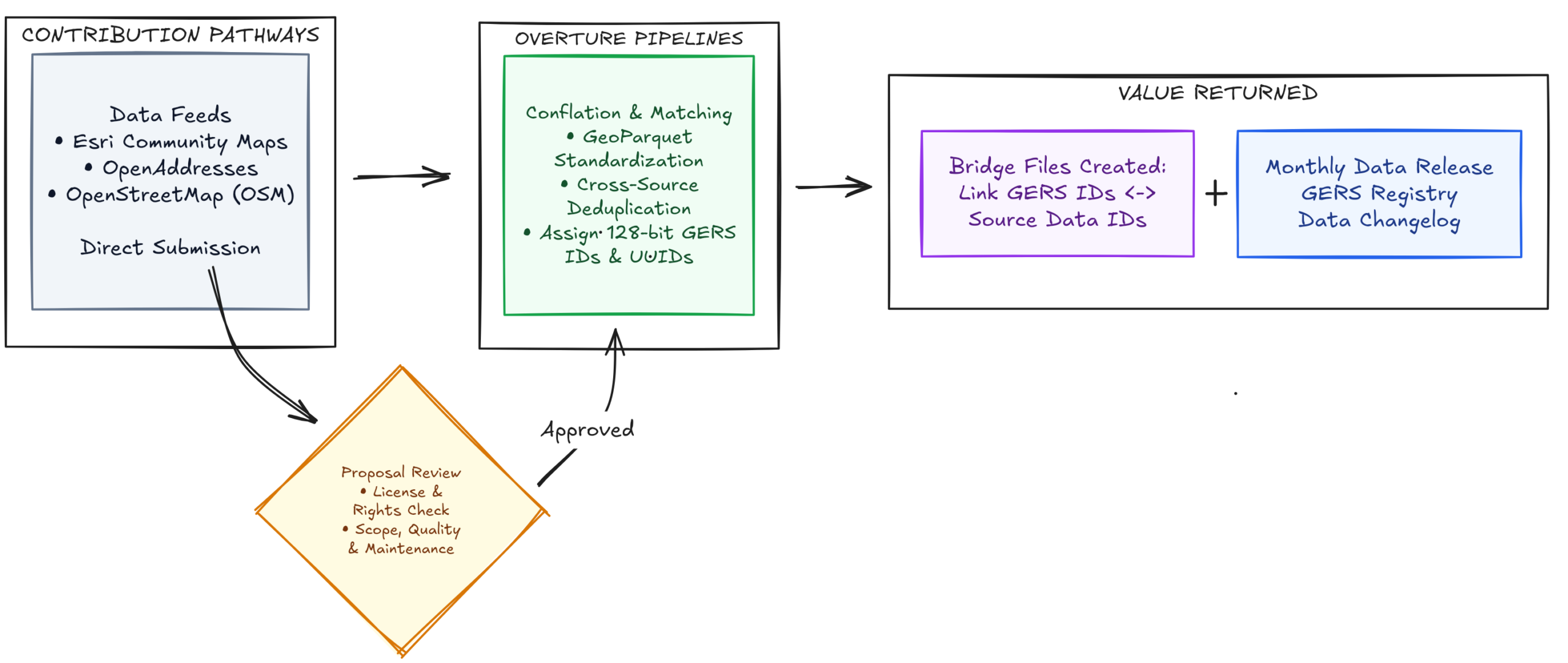
Figure 1: Contribution Data Pipeline
The Integration Process and Current Gaps
Initial Data Onboarding
For both use cases, the initial data onboarding presented a primary hurdle: transforming raw datasets from the City of Vancouver and Fresno County into standardized GeoParquet format. This structural alignment is a prerequisite for Overture to assign stable Global Entity Reference System (GERS) IDs and smoothly incorporate the features into the monthly global releases. While this ingestion pipeline currently requires manual engineering support, Overture is actively building toward a self-service directory model.
Beyond initial onboarding, the technical team at Esri Canada confronted a pervasive industry challenge during data ingestion: geometric segmentation variations.
Overture’s automated building footprint matcher utilizes a standard threshold of a 50% spatial area overlap to define a match between features (such as OpenStreetMap data and Microsoft ML building footprints). By contrast, Vancouver’s data was generated via automated LiDAR captures. It occasionally grouped continuous physical structures – such as strip malls comprising 10 distinct storefronts – into a single large footprint polygon. OpenStreetMap data on the other hand frequently mapped these as 10 separate, business-specific polygons.
Because the individual small polygons did not meet the 50% overlap rule against the massive LiDAR polygon, some elements initially dropped out of automatic matching – meaning they would not receive GERS IDs. Currently, there is no quick fix that allows the data to be manually edited. Overture is looking at ways to make the matcher more sophisticated so that it can detect situations such as the one described. Following the May 2026 launch of its Places Imagery Task Force – which uses satellite and street-level imagery to establish ground-truth POI data – Overture is evaluating whether a similar image-based approach can be taken to improve building footprint locations.
Ingestion Workflows
While early data ingestion highlighted gaps which Overture still needs to address, the process once data was ingested has driven an evolution at both organizations toward advanced cloud-native file formats and automated ingestion workflows:
Modern Formats: The City of Vancouver adopted the Cloud-Optimized Parquet format to align with Overture’s schema specifications, while Fresno County deployed its Cloud-Optimized GeoParquet equivalent.
Automated Ingestion Pipelines: Both agencies streamlined their upload frameworks. Data providers now drop updates directly into scalable cloud storage buckets (such as Amazon S3) using standardized directory naming conventions and incremental versioning.
Conflation Merging: Overture’s reliable monthly release cycle automatically ingests, validates, and conflation-merges these modifications into the global dataset.
Results & Post-Integration Impact
Data conflation is the hardest part of geospatial; Overture has done it at global scale, and agencies get to lean on that work. By shifting to Overture’s open ecosystem, both public sector bodies have unlocked immediate operational returns:
- The Interoperability Multiplier: GERS doesn’t replace anyone’s existing systems. It’s an open layer that sits underneath them, so datasets – proprietary or open, enterprise software or municipal databases – can reference the same places and actually work together. In the case of Fresno County and the City of Vancouver, Overture and GERS act as a single basemap, linking across Next Generation 911 (NG911), the Federal Highway Administration (FHWA) countrywide datasets, and local programs.
- Frictionless, Rapid Distribution: Administrative overhead has been reduced. Fresno County can update its registries weekly with zero added manual workload, while Overture partners instantly ingest the data – placing authoritative records into commercial use significantly faster than traditional pipelines.
- Global Base Data Enrichment: By mapping local municipal records to GERS-enabled building footprints, the City of Vancouver demonstrated how a city can link independent core databases – such as public works, building permits, and zoning assets – without forcing extensive database schema overhauls.
- Improved Accuracy: Inaccurate satellite-derived features were successfully corrected using precise municipal footprint data. During recent public safety crises, emergency departments utilized Overture’s compiled building footprint layer to expose precise structural locations previously hidden entirely beneath heavy forest canopies.
- Resolving Machine Anomalies: GERS IDs provides Fresno County and the City of Vancouver the real-world ground truth required to eliminate automated mapping errors. Local updates are systematically run against Overture’s master corpus. When an entity is verified across multiple layers, Overture collapses duplicates into a single, verified spatial feature – overwriting machine-learned anomalies with validated physical footprints.
Here’s an example of what that administrative overhead reduction looks like in practice: Ryan Lopez at Fresno County built a custom ArcGIS plugin that pulls Overture’s map data straight into ArcGIS Pro for any area and theme he picks – no more manual data wrangling to slow his team down.
Proof Point: The recent Sierra Nevada wildfire study:
The sheriff’s department needed to identify structures in a fire-prone stretch of the county’s Sierra Nevada area. Accurate footprints are hard for a county to produce (satellite, LiDAR). Fresno County ran a small study – structures within a ~3-mile radius of a campground – using Overture’s conflated buildings (Open Street Map plus Microsoft, Esri, others). It surfaced structures that single-source data missed; much to the surprise of the responders.
“What sets Overture apart is the level of quality behind the data. It brings together multiple trusted data sources, applies rigorous QA/QC, and delivers everything in a consistent, stable schema that’s much easier to work with.”
Steve Moore, Senior Product Engineer, Esri
Lessons Learned & Future Roadmaps
Isolated local data is valuable, but its true real-world efficacy is maximized only when it can work alongside other datasets to support different use cases – be it emergency services needing to find the fastest route to save lives or urban planners trying to determine whether a building is secure enough to renovate.
Open mapping data allows public agencies to retain control of their data while ensuring it is frequently updated and enriched by other data sources.
Moving forward, both the City of Vancouver and Fresno County are exploring how to further embed GERS IDs into their local registries, establishing a synchronized entity reference loop across a persistent geographic backbone.
Esri aims to scale these foundational blueprints globally. The goal remains focused on assisting national, state, and local government agencies to confidently GERS-enable their regional content, providing the global community with a more accurate, collaborative, and interoperable map of the physical world. The long-term path includes scaling these open reference systems beyond buildings to road and street centerline networks via state transportation initiatives, forging an interoperable foundation for the next generation of mapping.
Want to learn more about Overture Maps?
If you are interested in linking your municipal or enterprise data to a shared basemap, distributing authoritative updates faster, and resolving duplicate or machine-learned mapping errors with GERS, go to our Contributing Data to Overture page to learn how to get started.
The future of mapping is open, collaborative, and built together. Join us in making it happen. Visit our website to learn more about our work, and become a member.
Stay connected: follow us on Linkedin, X, and Bluesky for the latest updates. Sign up for Overture’s monthly newsletter for exclusive updates on our technical progress and community initiatives.
